

Project completed: P053_Kenya_Uganda
Marine spatial planning for sustainable use of Lake Victoria
Cooperating countries: Kenya, Uganda, Austria
Coordinating institution: Maseno University, Kenya, Oscar Kambona Ouma, kaudo2015@gmail.com
Partner institutions: University of Natural Resources and Life Sciences, Vienna (Austria), Nkumba University (Uganda)
Project duration: 1 April 2022 - 31 March 2024
Budget: EUR 25.393,33
Abstract:
Lake Victoria is a shared water resource faced with growing environmental stress that threatens to stifle the ecological services it provides and socio-economic activities. It supports about 35million people who live within its hydrological footprint. The lake as a resource is shared by Kenya, Uganda and Tanzania and covers approximately 68,800 km2. Currently, a spatial plan for the lake is non-existent. A project is proposed under the Austrian-African Research Network comprising of Maseno University (Kenya), Nkumba University (Uganda) and University of Natural Resources and Life Sciences (Austria) to undertake a research that will lead to spatial planning of Lake Victoria.
The partnership aims at facilitating mutual transfer of knowledge, research expertise and skills that will ultimately address development gaps especially in the South. The study will address the following research questions: (i) How has the land use and land cover changed over time around the Winam (Kenya) and Jinja(Uganda) Gulfs respectively?; (ii) What will be the projected impacts of land use and land cover changes on water quality of Lake Victoria?; (iii)What is the seasonal variations in water quality characteristics within the Winam (Kenya) and Jinja (Uganda) gulfs?; (iv) How do the water currents affect the dispersion of the pollutants in Winam(Kenya) and Jinja (Uganda)gulfs?; (v) How does Lake Victoria water quality influence anthropogenic activities within Winam(Kenya) and Jinja(Uganda) regions respectively? and (vi) What are the policy, legal and institutional gaps in the governance of Lake Victoria Resources?
The resultant information will be used to train critical mass of professionals to address varied issues to ensure sustainable spatial planning and management of the lake. The generated knowledge will be shared with the governments of respective countries and other stakeholders to inform policymaking with regards to spatial planning and management of Lake Victoria.
Summary:
Maseno University – Kenya
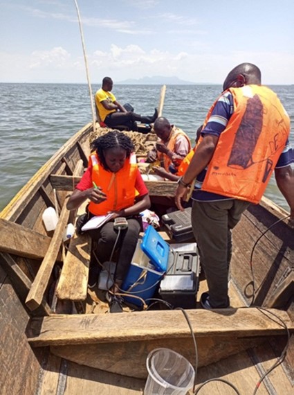
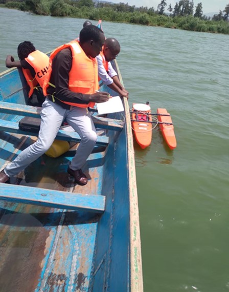
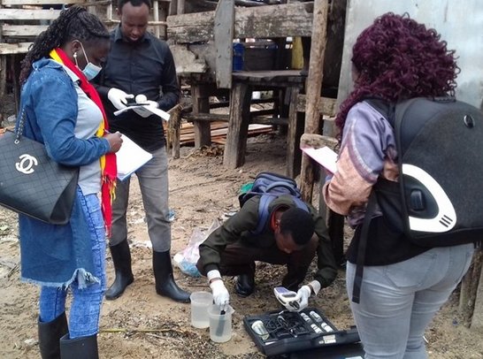
Lake Victoria water quality monitoring was carried out for the four seasons of the year in Winam gulf on the Kenyan side starting in October 2022, January 2023, May 2023 and Sept 2023. Collection of water samples from the 16 stations within Winam Gulf was undertaken using hired marine motorized boats from the Beach Management Units (BMUs). Water samples were collected using Van don water sampler. The results indicate that the Winam Gulf is currently experiencing low dissolved oxygen concentrations at some of the areas. Algae blooms, suspended solids and benthic organisms were also observed within the Gulf region. This is an indication that the Lake might have undergone upwelling mixing and therefore re-suspending the benthic material while at the same time stirring the bottom anoxic water into the top water column. Through focus group discussions, the community revealed that the Lake was dwindling in fish catch. This, they attributed to use of illegal fishing gear and pollution from sewer treatment works and industrial wastes. The study further explored land use in the Lake Victoria basin using classification on sentinel data of February 2023 using ArcMap software. The classification indicated that the largest land use in the basin is agriculture covering 8309.61 square kilometres representing 65.82% of the total area. Water covered 1767.54 square kilometres representing 14% of the landmass. Forests covered an area of 2257.34 square kilometres which is 17.88% of the total area. Built up covered 185.21 square kilometres which represents 1.47% of the land mass, and wetlands covering 103.70 square kilometres which represents 0.82% of the total area. Land use around the basin has implications on the water quality of Lake Victoria. Runoff from agricultural land and wastes from industries and waste water treatment plants find their way into the Winam gulf thus causing pollution of the Lake.
Nkumba University, Uganda
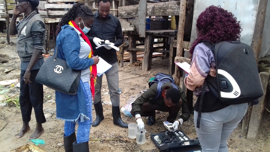
Lake Victoria is a fresh water body that is a shared resource by Kenya, Uganda and Tanzania. It provides ecological services and supports socio-economic activities to about 35 million people who live around it. Studies were conducted in the Winam and Jinja gulfs found in Kenya and Uganda respectively. In Uganda, Anthropogenic activities such as agriculture, fish handling, fish farming, water treatment, trading, tourism and urbanisation within the Jinja basin are affecting the water quality. The basin has undergone changes over the past four decades which has affected the physical, chemical and biological state of the gulf waters, hence altered provision of goods and services. Water samples collected during both the dry and wet seasons from the Lake shores exhibited varied physico-chemical characteristics. The average pH of the water samples was mainly alkaline, the lowest being at the BIDCO (8.21) while the highest was at Rippon fishing village (8.62). The DO, registered highest average values at Masese landing site (6.10) and lowest at Rippon fishing village (5.95). The average TSS was highest at the BIDCO (33.2) and lowest at Masese landing site (32.1). The average TDS values from all the sampling points were all high, the lowest being at Masese landing site (322 ppm) while the highest was at the BIDCO (328 ppm). The average heavy metal concentration results showed that Pb was highest at Masese landing site (0.40 Mg/l) and lowest at Rippon village (0.18 Mg/l). Cd was highest at Rippon village (0.007 Mg/l) and lowest at Bidco (0.005 Mg/l). Hg was highest at Rippon village (0.42 Mg/l) and lowest at BIDCO (0.31 Mg/l). All the water samples registered some presence of Enterococcus spp, E. coli, Staphylococcus aureus, Shingella spp and Klebsiella spp, a sign of contamination. All parameters sampled and analysed showed significant differences across sample sites, depth and in different seasons. The Masese landing site and Rippon fishing village are the hotspots having higher values in most parameters. The results obtained call for a need for further assessment for the all the East African countries in order to inform policy decisions for sustainable lake utilization by incorporating marine spatial planning concepts. This requires a transboundary planning and governance approach at the county, national and regional levels.